Kilmore: Victoria’s Earliest Inland Town
An Early History
First Settlers
Charles Bonney, who overlanded from Sydney in early 1837, was probably the first white settler in the Kilmore district. He originally settled closer to Glenaroua, but after an encounter with two bushrangers he moved closer to where Kilmore is today, settling there sometime in 1837. Bonney’s sheep station was known as the ‘Out Sheep Station’ or ‘Out Station’, being the farthest settlement from Port Phillip, “there being no other station within a distance of 20 miles”. Experiencing difficulty in hiring labour, Bonney consequently abandoned his station and moved to Mt. Macedon.
Other early squatters that followed were Dr. Richard Hamlyn, who squatted on the Dry Creek near Kilmore in 1837; Frederick A. Powlett and John Green had squatted just north of Kilmore; William Hamilton was on the Sugarloaf Creek and Alexander Mollison at Pyalong, all by 1838.
The Mail Run
By December 1837 a mail run was established between Sydney and Melbourne, with the overlander (and later squatter), Joseph Hawdon the contractor. His employee, John Conway Bourke was the first mailman to travel the route. Charles Bonney’s ‘Out Sheep Station’ was the stopover on the second night out from Melbourne. The Sydney Road was becoming a well-used route by men overlanding their cattle and sheep from Sydney. The site where Kilmore would emerge in subsequent years was a favourite sheltered camping ground and watering hole.
William Rutledge’s Special Survey
In 1841, Irishman William Rutledge purchased by Special Survey, 5120 acres (or eight square miles) of land at one pound per acre from the Colonial Government. In the SE corner of the survey, township allotments of about one acre, and suburban lots of 20 acres were mapped out.
William Rutledge named the town Kilmore, after his home town in County Cavan. Translated from the Gaelic, the name Kilmore comes from ‘Kil’ –cell, burying place, church and ‘Mor’ –big church.
Victoria’s Earliest Inland Town
By September 1841, the Port Phillip Gazette advertised allotments in the “Kilmore Special Survey” for sale by auction. Kilmore’s future seemed assured, with its prominent position on the Sydney Road, a plentiful source of water and rich volcanic soil. However, the depression of 1841 halted progress for a time with sale prices not reaching an acceptable price to the vendor. Instead, Rutledge leased allotments, mainly to Irish farmers, with an option to buy later.
By 2 May 1843 when Rutledge began to sell off the survey it was known as “the township of Kilmore”. In December 1843, Rutledge disposed of the remainder of the survey to three Sydney-siders, John Lamb, Allan McGaa and William Carr who subsequently sold the remaining land.
Rutledge’s Special Survey was also known as the Willowmavin Survey, the Kilmore Survey and The Survey. Today, we know most of the area contained within the survey as the Parish of Willowmavin, or to the locals simply, Willowmavin. The northern part of the Kilmore township, north of the Lancefield road, and west of East Street, is contained within Rutledge’s original special survey.
A Thriving Settlement
Before long, canvas tents gave way to more permanent buildings and Kilmore was a thriving settlement of farmers and those employed in servicing the farming community and travelling public; boot makers, blacksmiths, carpenters, livery stable keepers, storekeepers, boarding house and hotel keepers lined the Sydney Road at Kilmore.
Impact of Gold
With the discovery of gold came the demand for more food to be grown locally to feed the masses pouring into the new colony. By 1851 some 3000 acres of wheat were being grown in the rich earth on the Kilmore Survey. A total of three flour mills were built in Kilmore, the earliest in 1847, and these serviced grain growers for many miles distant. J.A. Maher, in his book A Tale of the Centurydescribed the area around Kilmore as “the granary of the young colony”. It was not unusual to see 50 bullock teams laden with wheat heading towards the three mills at any one time.
During the 1850’s and 60’s vast numbers of coaches and bullock teams lined the Sydney Road on their way to the Beechworth and McIvor (today’s Heathcote) goldfields and beyond. Come sunset, it was not an uncommon site to see a line of teamsters camping on vacant blocks from one end of the town to the other. Several coach lines began and ended their journey at Kilmore; many more passed through enroute to the goldfields or towns on the Murray River. Numerous hotels and associated businesses sprang up to service these travellers and Kilmore prospered as a result.
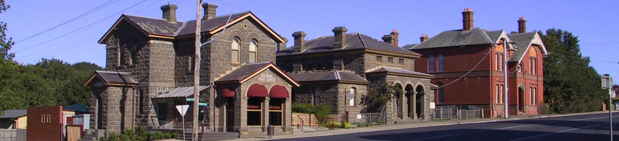
With increased prosperity and population came the need for more permanent buildings and social organizations. It was during the 1850’s that the majority of Kilmore’s more substantial buildings were built, many of which still stand today. The churches, hotels (up to 32 in Kilmore and surrounds), the gaol, the first courthouse (it later burnt down), banks, the hospital, mills, and breweries were all built in the 1850’s. Social organizations such as the Mechanics’ Institute and Free library, and the Total Abstinence Society were established, as was Kilmore’s first newspaper The Kilmore Standard of Freedom.
The New Township or Government Survey
In 1850 Government surveyor, Henry Bourn Foot surveyed further land south of the existing Kilmore township. These town allotments were first sold by auction on 11th September 1850. The town, south of Foot Street/Lancefield road is in the Parish of Bylands and was known for many years as the New Township (also Newtownship) or the Government Survey (as opposed to Rutledge’s private survey). With the subsequent building of the post office (1863), courthouse (1864), and the police barracks, and the southward relocation of the banks The New Township, particularly at the corner of Sydney Street and Foot Street (now Skehan Place) became the business centre of the town for many years.
By Heather Knight
Suggested reading:
Tucker, Maya Kilmore on the Sydney Road Kilmore, Vic. Kilmore Shire Council, 1988.
Maher, J.A. A Tale of a century 1837-1937 Kilmore, Lowden, 1972 (reprint with index)

I am interested in finding out the name and location of a property owned by George Faulks round First World War near Wandong. He had a son Frank. Thank you . Adele
LikeLike
Hi Adele,
Thanks for your interest. Have you tried searching in Trove (trove.nla.gov.au)? Many Victorian papers including the Kilmore Free Press have been digitised by the National Library of Australia. A quick search using the terms “George Faulks Wandong” will present a number of positive results from which it can be deduced the property was known as “Viewbank.” Using other search terms/strategies may reveal further information. The following article may be of interest – 1923 ‘DEATH OF A PIONEER.’, The Independent (Deniliquin, NSW : 1901 – 1946), 29 June, p. 2, viewed 18 May, 2015, http://nla.gov.au/nla.news-article101557498
The Kilmore Historical Society does have a Research Service, the details of which are provided on our Research Service page (https://kilmorehistory.wordpress.com/research-service/). You could email kilmorehistoricalsociety@gmail.com for more information about this service.
LikeLike
Thank you for your help. I have found some information from Trove. Adele.
LikeLiked by 1 person
I am currently tracing the Knight/Joiner families from Kilmore. Could you suggest some reading material that could help me connect with my family in a more personal way, then just having their names.
Thank you
Suzie
LikeLike
Thank you for your message Suzie. On this page https://kilmorehistory.wordpress.com/kilmore-and-district-ww1-soldiers-and-nurses/ there are three Knight WWI profiles. There are several Knight references in the books “Kilmore on the Sydney Road” and Kilmore – Those that came before”, see Publications page on this site. Also available is a CD on the Joiner Family for $10 +p&p by a Joiner descendant. I also suggest you search the Kilmore Free Press on Trove – newspapers.
LikeLike
My mother was a Knight .. Seaton Caroline Knight.. My Grand -mother was Margaret Knightand she was married to John Knighton the 15th of April 1903 at 15 Princes St. Flemington ,before moving to Taradale then Tantaraboo ,and finally Dandenong . We are related to the Knights, Joiners , Raeand quite a few more from round Kilmore/Willowmavin and Tantaraboo.
LikeLike
Thanks for sharing Robert; hopefully you may make some more contacts here.
LikeLike
Thank you very much. Where do I purchase the cd from?
You have been incredibly helpful, thank you.
LikeLike
Hi Suzie
From our Society – details are on the Society’s web site. Post address is P O Box 206, Kilmore 3764.
Grahame
LikeLike
Hi,
I have GGG grandparents
Edward and Judith aka Julia King nee Walsh that settled in Kilmore at 1857.Apparently Edward stayed in Kilmore until his death,but I can’t find any records of him or Judith being buried there.
He was born at 1820 died at 1878.Came from Tulla County Clare
Judith b 1820/30 d 1862/70 she came from Kilkenny.
There are King’s buried in the Catholic Burial ground who are related.
Also Alexander and Mary Anne Deeves are my other GGG grandparents.
Have you any history of the Kings or Deeves
Thank you.
LikeLike
Hi Jacky, I have passed your request on to our researchers. Both names sound familiar so I think we will have some material.
Francis
LikeLike
Hi Jacki, could you please send us an email to kilmorehistoricalsociety@gmail.com
That way it is easier for us
to respond
LikeLike
Hi, I wanted to find out who White Street in Kilmore is named after. If you could assist it would be appreciated.
Helen
LikeLike
Hi Helen – Thank you for your enquiry re White Street – we cant be absolutely sure but it is probably named after Edward Riggs White, surveyor, who died in Kilmore in 1853, or his father Henry White died 1844 – Grahame Thom
LikeLike